At what cost? So, we were saved from the storm here as I reported yesterday. But as I view the damage which took out our neighboring county, part of me can't help but wonder at what cost? It is a level of survivor's guilt I guess; a "there but for the grace go I" feeling. It saddens my heart that they suffered so that we did not.
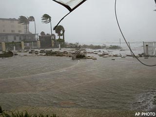
Fort Myers Beach
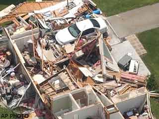
Home in Port Charlotte
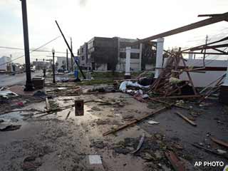
Punta Gorda
It feels strange to see it and know that it was meant for us. The bullet doged. The crisis averted. (More images here)
Ironically today it's been raining. We went out to run a few common Saturday errands and encountered a flash downpour. The irony is that yesterday, the day we were supposed to face the wrath of the catagory 4 storm, and as our neighboring counties instead felt it's power, we sat dry and calm.
For us, it's over Today has come and gone. No winds, no rain, no power outages. No panic, no flooding, no damaged, no storm surge. Evacuations have been lifted for several counties and people are free to return to their homes.
We sat in the direct path of the storm. A storm almost as bad as they come. And Fate intervened. It turned just slightly from it's due-north path to the east. Hitting land south of us and saving us from it's wrath.
So calm has it remained all day that it seems surreal. The map shows it so close and yet we sit, still, quite and restful.
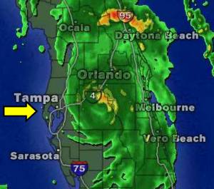
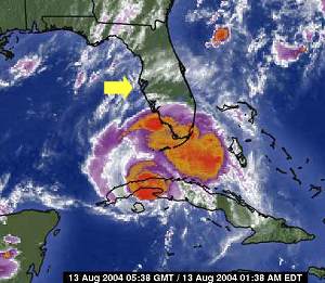
The storm rips through the state, but leaves us (yellow arrow) untouched
It is nothing short of a miracle for those of us here. And a nightmare for those to our south and south-east. Many people who fled this area for points inland are not dealing with what they had thought to outrun. Orlando, while inland and as such, feeling a weakening storm, is still awash in heavy rains and high, high winds.
As the sun sets on this day, it's hard to express my feelings on it. Dread and worry and constant waiting, only to find last minute deliverance. The build-up that never gave release. Do not misunderstand, I am not saddened that the hurricane spared us, just, I feel so spent after such continual vigilence.
Spared we were though. No damage. No rain. No winds. An eerily calm day that failed to birth the monster we had all be dreading. The local NBC network is airing the Olympic Opening Ceremony after finding little left to talk about. So off I am to watch that.
So for now, this concludes the chronicalling of Hurricane Charley. Another bullet dodged and another disaster averted. The storm that could have been but wasn't. I know our neighbors to the south and south-east only wish they could say the same and my thoughts go out to them. Thank you all for your kind wishes. Who knows? Such things might have helped shape the course of this storm.
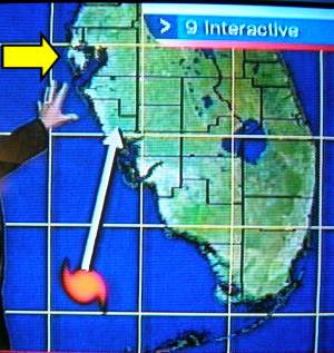
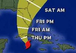
Bad News, Good News The bad news is that it went to a catagory 4. That's heavy shit. Winds at 145mph. The good news it that the path has changed! It's hitting south of us now, and NOT directly us! Oh thank goodness!
White = new projected path. Yellow = me
They're still expecting hurricane-force gusts of wind (75mph+) but...no major storm surges (which are expected to get upwards of 20 feet!) and far reduced damage.
Waking, Watching, Waiting I went to bed some time after 3am. And then something woke me up about 8:30am though I didn't get out of bed until about 9am. I just couldn't fall back asleep.
Checked the weather of course when I got up. It's still projected to hit us directly. They're saying about 2pm onward through the evening now. Updated and possiblely altered paths are being rumored after 11am, but nothing overly dramatic. We're still in the direct path of the storm. And it's definately getting closer though our wait continues.
The yellow arrow is where I am admist all this.
It's looking a little more like a stormy day outside, though it's more overcast and yucky out then truly menacing.
Friday Morning, 8/13/04 @ 10am
And if all this hurricane stuff isn't bad enough? I think I'm coming down with a cold. My nose was bugging me all day yesterday and my right ear was all clogged up, but I assumed it was just a minor allergy thing. Often times, for no reason, I just have a day here or there where my nose turns on the waterworks. I assumed yesterday was such a day. But it seems that it's much worse this morning (part of why I couldn't get back to sleep was my nose) and besides not having gotten enough sleep, I'm still really tired and run down. Dammit. Like all I need is to have a cold during the storm. Bah.
Anyway, I took some Benedryl (it was either that or the Claritin in the house but if I take that I literally can't sleep for 24 hours from it) and I think it's starting to kick in. Not kink in as in helping my nose, mind, but rather, kick in like making me drowsy. (I know, helpful, right?)
So just a check-in from me. Pending on how quickly the storm comes today I may or may not have a chance to post later. Turning on my pc is a ten minute process on it's own and with looming threats of power loss, who knows what will happen.
All's Calm Still eerily calm outside. But Charley is looming closer. A quick glance at the weather.com maps made that pretty obvious:
(once again, the yellow arrow is where I am)
Love conked out during the movie. So I put him to bed and figured we'd finish it tomorrow. *crosses fingers for minimal power outages*
I think the next update for the National Weather Service comes at 3am so I might read that then hit the sack myself.
This is what they're officially saying for us to expect in my area at the moment though:
Overnight: A 20 percent chance of showers and thunderstorms. Mostly cloudy, with a low near 79. South wind between 6 and 8 mph.
Friday: A slight chance of rain and thunderstorms, then periods of rain and possibly a thunderstorm after 8am. Some of the storms could produce heavy rainfall. Chance of precipitation is 100%. High around 85. Windy, with a south southeast wind 8 to 11 mph becoming east northeast between 40 and 43 mph. Winds could gust as high as 52 mph. New rainfall amounts between one and two inches possible.
Friday Night: Periods of rain and possibly a thunderstorm before 2am, then rain and thunderstorms likely after 2am. Some of the storms could produce heavy rainfall. Chance of precipitation is 100%. Low around 79. Windy, with a northwest wind 99 to 102 mph decreasing to between 31 and 34 mph. New rainfall amounts in excess of four inches possible.
I love how they start off with tonight, winds between 6-8mph. Then they get into Friday and it's 40-43mph, right? But then, Friday night they try to sneak it in on you - winds 99-102mph. Gee thanks.
Oh they also make a point to remind us that the following hazardous weather conditions are in effect: Flood Watch Hurricane Warning Tornado Watch
Um, yeah. I think we figured that much out already too. Heh. Anyone wanting news from the official National Weather Service themselves can hit this page: http://www.srh.noaa.gov/tbw/
I'm calling it a night for now. Hope to report more interesting material tomorrow (though I hope not too interesting or it probably means I'm without power). At the very least, I'll be snapping pictures and I'll get back with you as soon as I can. Take care everyone and be safe!
For those keeping track... I feel like a news distribution network here. Heh. Some updated (and elevated) warnings:
Severe weather alert from the national weather service ...hurricane charley local statement national weather service tampa bay area - ruskin fl 1138 pm edt thu aug 12 2004
... Intensifying hurricane charley may be a dangerous threat to the suncoast friday...
... Hurricane warnings for the entire west central and southwest florida coastal area...
... The inland hurricane wind watch has been upgraded to a inland hurricane wind warning for west central florida.
... A flood watch is in effect for all of west central and southwest florida...
... A tornado watch is in effect for charlotte and lee counties...
A hurricane warning has been issued for the following locations in west central and southwest florida: Citrus charlotte de soto hernando hillsborough lee levy manatee pasco pinellas sarasota including... The coastal waters from bonita beach to the mouth of the suwannee river... Charlotte harbor and tampa bay.
An inland hurricane wind warning is in effect for the following locations in west central florida: Hardee highlands polk sumter
The rest was pretty much the same as before. Things like it being a warning rather then just a watch though have changed.
Also, there's the following flood alerts now being posted as well:
Severe weather alert from the national weather service ...flood watch national weather service tampa bay area - ruskin fl 1010 pm edt thu aug 12 2004
... The flood watch remains in effect until 500 pm edt saturday afternoon. The watch continues for the following counties...
Charlotte... Citrus... De soto... Hardee... Hernando... Highlands... Hillsborough... Lee... Levy... Manatee... Pasco... Pinellas... Polk... Sarasota and sumter.
Some cities in the watch include...
Arcadia... Bartow... Bradenton... Brandon... Brooksville... Cape coral... Chiefland... Clearwater... Clearwater beach... Fort myers... Inverness... Lakeland... New port richey... Port charlotte... Punta gorda... Sarasota... Sebring... Spring hill... Tampa... Venice... Winter haven and zephyrhills.
... Synopsis... Hurricane charley will move into the eastern gulf of mexico late tonight and then move across west central and southwest florida on friday and friday night. Hurricane warnings have been issued from bonita beach in lee county to bayport in hernando county. A hurricane watch remains in effect from bayport to the suwannee river in levy county.
Rainfall totals of 4 to 8 inches are expected with hurricane charley. This additional rainfall will aggravate already saturated ground conditions across much of west central and southwest florida. Moderate river flooding as well as moderate urban flooding is possible.
A flood watch means flooding is possible during the next 24 to 36 hours. Residents living in flood prone areas... As well as those living near small streams and creeks... Should take action to protect property and be prepared to move to higher ground.
Stay tuned to noaa weather radio and other local media for updates and possible warnings.
Ugh. 4-8 inches of rain. We don't need it right now I can assure you. Hopefully, since we're not around any lakes or rivers we should be ok. But I can certainly see many residental neighborhoods flooding not to mention the major North-South route of US Hwy 19 which always badly collects water. Could make any last-minute or unexpected evacuations a real nightmare. Not to mention people who'd need to cross a bridge to get inland. Eep.
It's still really, really calm outside. I think we're going to watch a movie. Rosencrantz and Guildenstern Are Dead actually came on one of the Showtime channels last night (what...? something on the pay movie channel we actually want to see? How freaky is that?) so I recorded it. It's been years and years since I've seen it so I'm looking forward to it.
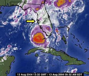
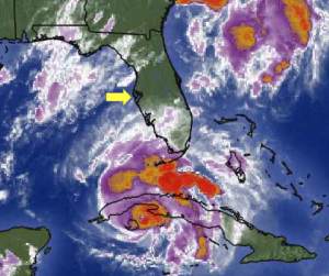
Eerily Calm It's so strange. It doesn't look or feel like a hurricane is barreling our way. Outside right now the skys are clear and while it's a bit excessivly humid out, it's not all that bad. Even the radar is deceiving:
No storms in the area
It's all quite and clear. But when you look at the bigger picture, things suddenly change.
The yellow arrow is pointing to me
Holy crap, you mean all that is coming my way? It's creepy. And I think about how it must have been in the years before the Doppler radar and satellite imagery. How they must have been taken so by surprise when something hit. How you wouldn't know what was coming until it was on-top of you.
Tonight brings new meaning to "the calm before the storm." I'm eager for this all to hurry up and happen. I just want it to be over. All of my local channels have pre-empted their programming to talk about hurricane safety, hurricane evacuation, constant weather updates, etc. It's unnerving to sit and watch and just wait.
Latest Update More fun warnings from the National Weather Service! They sure like to try to scare the bejebus out of you don't they?
Severe weather alert from the national weather service ...hurricane charley local statement national weather service tampa bay area - ruskin fl 538 pm edt thu aug 12 2004 ... Intensifying hurricane charley may be a dangerous threat to the suncoast friday... ... Hurricane warnings issued for areas south of bayport... A hurricane warning has been issued for the following locations in west central and southwest florida: Charlotte de soto hernando hillsborough lee manatee pasco pinellas sarasota including... The coastal waters from bonita beach to bayport... Charlotte harbor and tampa bay. A hurricane watch continues for the following locations in west central florida: Citrus levy Including... The coastal waters from bayport to the mouth of the suwanee river. An inland hurricane wind watch is in effect for the following locations in west central florida: Hardee highlands polk sumter ... Storm location... At 5 pm edt... The center of hurricane charley was located near 21.2 north... 81.9 west... Or about 465 miles south of tampa. Charley was moving to the north northwest at 18 mph... And is expected to gradually turn to the north over the next 24 hours. Maximum sustained winds are near 105 mph... And additional strengthening is expected as the storm moves out of the caribbean and into the gulf. Charley could become a major hurricane later tonight or friday. Minimum central pressure was 980 mb... 28.94 inches. ... Storm surge flood and storm tide impacts... With charley expected to intensify... Then accelerate... Along the suncoast... The threat of a rapidly developing storm surge in the storm's southern semicircle is great. Current indications suggest the highest surge will occur from the counties near tampa bay south to lee county. The current forecast track... Speed... And intensity suggest storm surges in some areas equaling or exceeding those experienced in hurricane donna in 1960 and the 1944 hurricane each of which made landfall north of fort myers... Or more likely the 1921 hurricane which made landfall in northern pinellas county. A storm surge of 10 to 13 feet is possible to south of where charley makes landfall. ... Wind impacts... Charley is forecast to intensify and could become a category three hurricane as it approaches the suncoast on friday... With winds in the inner eyewall perhaps at least 130 mph with higher gusts. However... No matter where the center crosses... Current forecast data suggest tropical storm force winds of at least 40 mph will affect all areas of west central and southwest florida between friday early saturday. ... Very dangerous winds will produce widespread damage... ... Destruction of mobile homes near the center of the storm is possible... ... Structural damage... The majority of mobile homes will be severely damaged near where the storm makes landfall. Houses of poor to average construction will have significant damage... Including partial wall collapse and roofs being lifted off. Many will be uninhabitable. Well constructed houses will incur minor damage to shingles... Siding... Gutters... As well as blown out windows. Partial roof failure is expected at industrial parks... Especially to those buildings with light weight steel and aluminum coverings. Older low rising apartment roofs may also be torn off... As well as receiving siding and shingle damage. Much of the glass in high rise office buildings will be blown out. Airborne debris will cause damage... Injury... And possible fatalities. ... Natural damage... All trees with rotting bases will become uprooted or snap. Nearly all large branches will snap... And major damage is can be expected to citrus groves... Including numerous uprooted trees... Most common where the ground is saturated. The next hurricane local statement from the tampa bay area forecast office will be issued around 9pm edt. Stay tuned to noaa weather radio for further information on this dangerous flood. Heed all evacuation orders from law enforcement or military personnel.
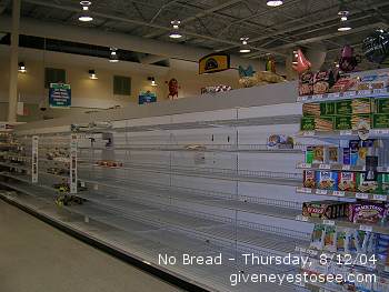
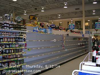
In other news, we just got back from the supermarket. No panicking here, just needed some dinner tonight and some food for tomorrow. Oh and some t.p. That's vital stuff to have. There were actually empty shelves. No bread at all and no water in site. The canned soups were pretty picked clean as well. Yours truly had her trusty camera with her and can show you what I mean.
No bread. None. Nada. Not even hotdog buns.
No water. Nothing bottled nor in gallon anywhere in the store.
At the moment the weather is HOT. It's also extremely BRIGHT and SUNNY outside. The humdity is way up there. No signs of rain clouds and no rain to speak of. The small shower earlier has not only disappeared, the water it left has already evaporated.
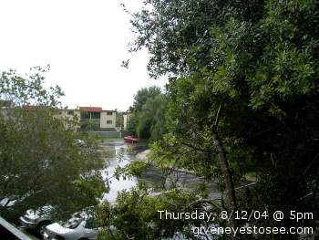
Continuing Coverage Well, Love came home. They closed up a smidge early and are closed tomorrow. Idiots. Took them forever to decide.
It's started to rain a little, though it's actually brighter out there then before. I'm just killing time waiting for the revised National Weather Advisory which should be by after 6pm.
shot from my balcony
I feel bad. A bunch of my online friends are already nervous for me. I think that a level of acceptance comes to you about things like storms and hurricaines when you've lived here as long as I have. People outside the area aren't used to it, so it's much scarier from their point of view. Ironic hu? Though I believe in being safe and smart during storms, I just don't get worried over them. Panic doesn't help in the slightest. I'm in the best place I can be in this area (the most inland and highest ground for a peninsula surrounded by both the Bay and the Gulf) and I'm not going to go out and risk anything in the storm. We'll just see how it goes.
Here's the latest from the National Weather Service for my area. If this doesn't sound like fun, well then I don't know what does! (sarcasm there folks)
Severe weather alert from the national weather service ...hurricane charley local statement national weather service tampa bay area - ruskin fl 301 pm edt thu aug 12 2004
... Intensifying hurricane charley may be a dangerous threat to the suncoast friday... ... Hurricane warnings likely to be issued by 5 pm today...
... The hurricane watch continues for the following areas:
Charlotte citrus de soto hernando hillsborough lee levy manatee pasco pinellas sarasota
Including... The coastal waters from bonita beach to suwanee river... Charlotte harbor... And tampa bay.
... Storm location... At 2 pm edt... The center of hurricane charley was located near 20.4 north... 81.5 west... Or about 515 miles south of tampa. Charley was moving to the northwest at 17 mph... And is expected to continue to move at around this speed while gradually turn to the north northwest over the next 12 to 18 hours. Maximum sustained winds have increased to 105 mph... And additional strengthening is expected as the storm moves out of the caribbean and into the gulf. Minimum central pressure was 980 mb... 28.94 inches.
... Storm surge flood and storm tide impacts... With charley expected to intensify... Then accelerate... Along the suncoast... The threat of a rapidly developing storm surge in the storm's southern semicircle is great. Current indications suggest the highest surge will occur from the counties near tampa bay south to lee county. The current forecast track... Speed... And intensity suggest storm surges in some areas equalling or exceeding those experienced in hurricane donna in 1960 and the 1944 hurricane each of which made landfall north of fort myers... Or more likely the 1921 hurricane which made landfall in northern pinellas county.
The exact location and strength of the surge should become more clear later today. For now... All coastal residents should be rushing to completion any last minute preparations this afternoon since a warning will issued this afternoon.
In short... A surge of 10 or more feet is possible in the southern semicircle of the storm just after landfall. Flooding may be highly dependent on the time and value of high tides on friday.
... Wind impacts... Charley is forecast to intensify to a strong category two hurricane as it approaches the suncoast on friday... With winds in the inner eyewall perhaps at least 110 mph with higher gusts. However... No matter where the center crosses... Current forecast data suggest tropical storm force winds of at least 40 mph will affect all areas of west central and southwest florida between friday morning and friday evening.
Details on specific damage impacts will be provided after hurricane warnings are issued after 5 pm today.
... Rainfall... Rainfall totals of at least 3 to 6 inches are likely beginning late tonight and continuing through friday night. In all areas... These rains will cause significant rises in rivers... Creeks... And streams. However... In areas near tampa bay where some rivers are in flood and all rivers are running high... Moderate to major flooding is possible during and after the passage of charley.
Flood watches have been issued for all of west central and southwest florida.
... Tornado impacts... A tornado watch is in effect until 9 pm this evening for areas east and north of tampa bay. This watch is largely independent of hurricane charley and related to teh interaction between tropical storm bonnie... Now decaying while racing toward the georgia coast... And deepening southerly flow around a building ridge off the atlantic coast.
There is a risk of tornadoes late tonight through friday evening from the outer rainbands of charley... Especially 50 miles or more away from the center of circulation. Tornadoes would be most likely beginning Friday and continuing into friday night well east and southeast of the center.
The next hurricane local statement from the tampa bay area forecast office will be issued around 6 pm today.
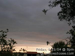
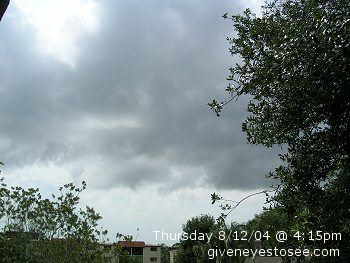
I'll keep up with the updates as long as power and cable and conditions permit. Right now it's breezy outside and there's some clouds in the sky. It's not overly sunny but it's not dark either. Actually, I take that back; it is getting a bit dark out there. Not exceptionally dark or anything, it gets darker then this on afternoon showers, but still. Here's a peek:
Thursday, August 12th 2004 @ 4:15pm
We should get more menacing reports after 6pm. Joy!
Hurricane Charley Joy. Last night I go to bed and it's on track to hit quite a bit south of me. This morning I get up and now it's shifted and scheduled to pummel the crap out of all the west central coast.
Yeah, this is where I live
And it's not often your weather forecast tells you a 100% chance of rain. It's not really a "chance" then is it if it's 100%
There's a level of deja vu involved here. In September 1998, when Hurricane George came through, we had to evacuate. At the time, I had just gotten together with my Love but, in an act of [regretable] kindness, I was still living in my rented house with the dickhead. We had broken up a few weeks before but he begged me to give him the rest of the month to make arrangements for a new place to live. I, being an idiot, agreed, trying to do the right thing.
So, where my Love and friend Rand lived was under mandatory evacuation. I helped them pack up and prepare. Love and I ended up on the road and into GA, finally ending up in Calaway Gardens for the weekend. It was a totally unplanned trip but the "official" start of our relationship. Because when I got back home, the dickhead had cleared out everything in the house and stolen all of my posessions and jumped ship - literally, left for a 3 month stint on a cruise ship. Fucker.
So it was a good and bad experience. Turns out, George never hit us anyway. Those who stayed said it barely rained. It turned at the last moment. Thing is, that I've lived here for almost 19 years. And George was the first real threat - a threat which never even panned out. Newscasters are making a lot of noise and comment to take this new Charley threat seriously. People in this area haven't been hit in most resident's lifetimes so they don't really have the sense of urgency that people outside the state probably would. Especially since everyone went so crazy panic over George who never even came close, it's hard to convince people there's any real danger.
I'm keeping my eye on it, but I'm honstly not that worried. We've had some horrible storms - like the No Name Storm of 1993 - come through that weren't even hurricanes or tropical storms that have been way worse then any official tropical warnings we've ever had. I'm sure we'll get rain. And some gusty winds and the beaches will get churned up. But, I think we'll - sorry, have to say it - weather the storm just fine.
If not and you hear about parts of Florida breaking into the Gulf, well....then all of you who panicked are welcome to say "I told you so."
Apartment Hell Saga Continues... Ok, so waaaaaaaaaay back on July 21st, they finally came out to stop my water leak (which had actually started on July 17th). On Friday, July 23rd they came out to do the air quality samples. Which the tech informed me would take five business days for the results.
Today is now August 11th and I've still not gotten the results.
The tech also recommended a second mold check after the wall was finished drying to ensure nothing grew during the drying process. (He also said they should bring in dehumidifiers into the bathroom to help in the process and curb any mold growth which they failed to do.)
So. Nineteen days after the air check, no results. No second test. No one has been in the building - not once - since the repair leak itself so zero work has been done to repair the damage done to the walls. I could have dangerous readings for over two weeks and no one has bothered to find out. It's not like I've not asked. I have. They keep saying they're leaving messages but not hearing back on the results. Uh hu. Right.
They sure cashed my rent check quickly though.
Addendum: So. I called the air quality company. He answered his cell on the first ring. (Surprise) And said he was sure he had sent them the results over a week and a half ago. He wouldn't give me a copy nor the results because of his contract with the complex.
At this point I was IM'ing my pal Cy who, upon hearing this replies , "Fuck this." He proceeds to call them on my behalf and they lie to him too! "We don't have the report." Of course, upon telling them the air quality company has already been contacted and they say the report has been sent, it's all backpeddling and more lies.
Anyway, she's now "looking into it" but at least their's a fire under her ass. Way to go Cy! (And Thank You!) Less ulcers for me if someone else deals with their bullshit and less chance I'd just stop pushing for information out of frustration and not wanting to deal with it anymore. Hopefully, we'll have some more information soon.
pointlessness When all else fails, post a picture of your cute tubby tabby cat.
In other news....my email says I can enjoy a free dell laptop, sticher inside market picks, that she will smile tonight and 2nd day air on all printer brands. Oh but I need to act now while rates are still low. What an amazing world we live in.
head Man my head is starting to really hurt. It's been getting worse for the last hour or two. It feels like a migraine is coming on. No clue why though, not like I did anything today (I just slept most of the day) and I certainly didn't have any of my triggers...bah. Fucking head. That's what's so great about migraines. You can do everything right and still get them.
Monday Yesterday was my mom's birthday. So today I went up to her place and from there we went to the craptacular old theater by her. We met up with my sister and my mom bought tix for The Village. (You know, the new one by M. Night Shyamalan.) It was ok - not with the big twist at the end like he normally does; just two small twists that you clearly saw coming. (Or at least I did.) It was subtle though and not a bad film, just not a great one either. My mom picked what she wanted to see and that's what she chose. It wasn't scary (her main worry) and it wasn't creepy or anything. Eh, it was decent enough I suppose though not great. And, thankfully, none of the barf-inspiring visuals of Borune Supremacy.
It's starting to rain. We've had a lot of rain lately with rain in the forecast all week. August is really our rainiest month though with over 8 1/2 inches on average according to weather.com. We're in the peak of hurricane season too so it's not unexpected. It just means even more power issues though and even less ability to safety run the pc. It's getting really old turning it on once a day.
It's the little things that keep getting to me right now. That keep me on the edge of the tears. I watch as my hair is literally falling out in clumps and I know I'm going to have to cut it all off again soon. This is the second time it's happened in my life. About five-six years ago it happened from a combination of poor health, stress and horrible water. It got so bad that about four years ago I chopped my hair - my beautiful, curly hair that I treasure and that is one of the only things I really like about myself - off to the shoulder. I had to. There was almost nothing left. Then it started growing back and I was so overjoyed. I never thought I'd get it back like that again. It grew long and thick and the curls really returned. I was so happy. Now I see it falling out not by strand but by clump again and I know I'm damned to lose it all over again. And most likely for want of vitamins and water filter. Why is it that such small things are so far out of my reach? Women's daily without iron (because I can't digest the iron) at 90 pills is about $18. The Hair, skin and nails is another $14 or so I think. Just a lot of money I don't have. I cry and it falls out and not only do I not want to cut it (but know I'm going to have to again), but find myself without the money to have it cut either.
The little things. They kill you.
Forget the looming panic over our car dying once and for all. Forget the worry every month over paying the bills. Forget we can't afford car insurance and so risk tickets (more money) and license suspention every time we drive. Forget failing health and absolute inability to see a doctor ever. Forget all of it. Watching my hair scatter all over the house and realizing how little is left on my head just hurts worse.